Looking at Puerto Vallarta Jalisco maybe five miles south.

On this blogger site one can click on all pictures except for the header above two times each time making them larger which is a feature I like because it gives you the ability to really look very close at all kinds of things not readily seen.

Tuesday, December 28, 2010

Xmas Cruise

Traveled down to the front range over the holiday weekend and on Xmas went for a ride ending up maybe 50 miles east of Denver. This particular picture is maybe 10 miles north of Silverthorne. The weather was so nice and no snow unlike the high country here. The sno-pack around Steamboat Springs is at 150% of average.
 The resident cat Tigger. He's a good kitty.
 
 I enjoy close ups and and given the blandness outside I'm looking for color. This is kinda fun to look at for a bit.
 This shot could be from a bunch of places some far away but it's here in Colorado.
It seemed we had to go a long ways before we really got away from city influence and there were many structures like this. These are not houses when built this large and elaborate.  

Remember about clicking on the pictures once and then twice if you want as they get bigger each time. I like the clouds in this one.
We saw two pheasants and having grown up in pheasant country it is always a pleasure to see one of these birds. The more the merrier as far as I'm concerned.
 I like this one as well if the tree wasn't quite centered it would be better. In the next you can tell we are quite a ways from the mountains.

 This was once a community as there was a couple small buildings as well.
 This was a post office at another place like Leader. The name escapes me. There are not many people out here. There were more at one time but agricultural practices changed that. 

 The directory. Some families have been here as you may well imagine for generations.
 We were treated to a pretty decent sunset when we started our return west.

Sunday, December 12, 2010

Trains Along The Colorado

River that is with one exception. Most were taken between state highway 131 and Interstate 70 at the Dotsero exit. A 35 mile stretch of road that follows the Colorado River and is called the Colorado River Road. The first two pictures are the exceptions to that. The first is the Colorado at State Bridge showing  highway 131 bridge. The second was taken at Trinidad,Co which is a few miles north of the New Mexico state line on Interstate 25.

This is probably my favorite place as I have fished here so much. It's very special. 


I like this picture a lot. The area above the train and to the north is known to the locals as Sunnyside because it does not snow there.

Friday, December 3, 2010

Highway 1 California

These are a few pictures taken on 3/24/09 driving along the ocean from Monterey to Santa Barbara a road never traveled by me. Totally enjoyed this and hope sometime to return when there is more time. California has always held a fascination to me because of the car culture,music and of course the ocean. After this trip for the longest time I felt a sincere need to move here. Maybe I should. Time is running out.

The last picture was taken in Pismo Beach. Had heard about this place and I ended the day there and stayed the night. I don't have to think as I know I could live there. Some of these pictures let me relive that day again.


Friday, November 26, 2010

Wupatki National Monument

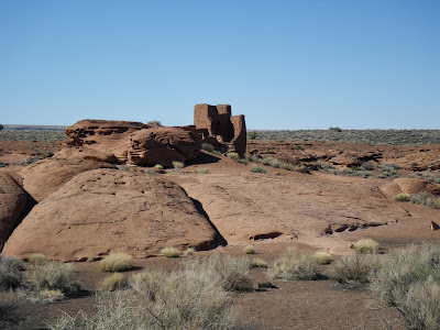
At the end of March 2009 revisited Wupatki National Monument for the what ever number of times because it is at the top of the list for favorite places to go that doesn't get old. Located just north of Flagstaff, Arizona it is on a 30 some mile loop road where in lies another National Monument.

There is a lot going on out here and you can get an idea of that by taking a close look at the first picture which is of the main ruins a short walk from the visitors center.There are ruins just along the road requiring only short walks to explore. What's better is to take walks away from the main sites and you will find many things if you have a observant eye. It's fun. Most of these are meant to be illustrative with a couple that are pretty good but when you click on them and they get bigger they're all fun to look at.


                                            Panoramas pass all.


             The black rocks are cinder rocks at a ruin built on a higher part of the valley floor called the Citadel.


This picture shows one of the reasons why Wupatki is different. This is a ball court the only one I've seen. When you are viewing it around it and particularly in it envision what it must have been like with a game being played. This is cool stuff.

Directly behind where you see the sign just a few yards is a blow hole another thing that is unique at least it's the only one of those I've been around as well. There isn't a picture but at the link there is.

Look what we have here. A picture of the very same blow hole courtesy of Cujo and Dana. Thank you so much! It's working quite nicely as you can see. It goes the other way as well.


                                           This is what much of the terrain looks like .


Here is the reason for the cinder rocks and the blackness of the ground. The other monument is Sunset Crater Volcano National Monument. There are volcanoes that popped off all over the place here and the picture at the top shows that.
Related Posts Plugin for WordPress, Blogger...